The FarmTree Tool
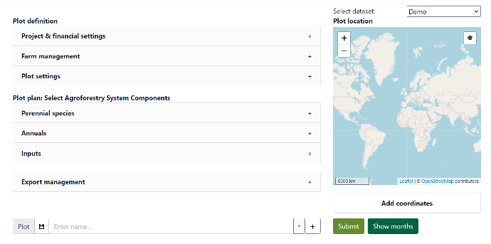
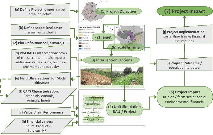
The FarmTree Tool is a software-based model with an online interface meant to enable land users and landscape stakeholders to design agroforestry systems, and project their performance in terms of production, financial, and agro-ecological indicators.
The FarmTree Tool combines site-specific farmer, plot, climate, soil and species data into a plot scenario, and generates projections for a desired period of time.
The tool be accessed by anyone for free with a FarmTree®Tool Demo account and a pre-set dataset. Licensed clients also receive a tailor-made dataset with the species and inputs relevant to their region, calibrated with local data upon request.
The Tool is under constant development of new functionalities and indicators to support different land users in their objectives.
Check the latest FarmTree Tool updates
FarmTree Tool Indicators
+90 key performance indicators directly linking to SGD goals
Ecological
Plot cover by species
Biodiversity
Water balance
NPK stock
Erosion
Growth limiting factors
Production
Fresh and Dry yields
Fresh and Dry yields per product category
Financial
Revenue by species
Input costs
Wages
Annual and cumulative balances
Balance per labour day
Social
Labour by gender
Labour by component
Carbon
Biomass accumulation
CO2e stock
Carbon Removal Units (CRUs)
CO2e revenue by species
The FarmTree Model

Agroforestry plot model
The FarmTree Model is divided into different sub-models interconnected to each other which simulate the different dynamics in the agro-system (soil model, nutrient model, water model, vegetation layer cover model, growth constrains model, biomass production model, carbon model and economic model).
Several datasets are combines (tool user input data, site-specific climate and soil data, and tree/crop biophysical variables) to generate the desired plot projections indicators.
Download the FarmTree Model Methodology
FarmTree landscape model
We aggregate plot projections from different scenarios to generate landscape-level impact assessment.
The landscape model allows to compare the combined performance of Business-as-Usual (BAU) plots versus alternative investment scenarios, such as agroforestry, to estimate total Project impact.
Components of Agroforestry Systems (CAFS) Database
FarmTree database consists of +300 agroforestry systems' components (perennial and annual species and inputs) defined by their most characteristic biophysical variables. With a FarmTree license you can access a certain number of the agroforestry system component records, and additionally you can request to calibrate them using your own local data. The species and inputs can then be mixed and matched in endless combinations in the tool, by adjusting:
density and time of species planting
amounts and timing of input application
plot management practices (thinning, pruning, irrigation, other costs and inputs, etc.)